


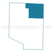
Dixon Voting District, Pulaski County, Missouri
About
Outline

Summary
| Unique Area Identifier | 609481 |
| Name | Dixon Voting District |
| County | Pulaski County |
| State | Missouri |
| Area (square miles) | 86.94 |
| Land Area (square miles) | 86.23 |
| Water Area (square miles) | 0.71 |
| % of Land Area | 99.19 |
| % of Water Area | 0.81 |
| Latitude of the Internal Point | 37.94826130 |
| Longtitude of the Internal Point | -92.11231180 |
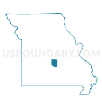
Maps

Graphs
Select a template below for downloading or customizing gragh for Dixon Voting District, Pulaski County, Missouri


Neighbors
Neighoring Voting District (by Name) Neighboring Voting District on the Map
- Crocker Voting District, Pulaski County, MO
- Hayden Heights Voting District, Maries County, MO
- Hooker Voting District, Pulaski County, MO
- Iberia Rural Voting District, Miller County, MO
- Jerome Voting District, Phelps County, MO
- Liberty West Voting District, Phelps County, MO
- Santee Voting District, Maries County, MO
- St. Robert Voting District, Pulaski County, MO
- Waynesville Voting District, Pulaski County, MO
Top 10 Neighboring County Subdivision (by Population) Neighboring County Subdivision on the Map
- Cullen township, Pulaski County, MO (38,431)
- Union township, Pulaski County, MO (4,751)
- Tavern township, Pulaski County, MO (3,349)
- Richwoods township, Miller County, MO (3,243)
- Arlington township, Phelps County, MO (2,289)
- Miller township, Maries County, MO (1,110)
- Dry Creek township, Maries County, MO (631)
- Liberty township, Phelps County, MO (355)
Top 10 Neighboring Place (by Population) Neighboring Place on the Map
Top 10 Neighboring Unified School District (by Population) Neighboring Unified School District on the Map
- Waynesville R-VI Schools, MO (36,404)
- Dixon R-I School District, MO (6,436)
- Maries County R-I School District, MO (4,026)
- Iberia R-V School District, MO (3,972)
- Crocker School District, MO (3,333)
- Newburg R-II School District, MO (2,888)
Top 10 Neighboring State Legislative District Lower Chamber (by Population) Neighboring State Legislative District Lower Chamber on the Map
- State House District 148, MO (42,602)
- State House District 147, MO (38,962)
- State House District 149, MO (38,305)
- State House District 115, MO (37,008)
- State House District 112, MO (34,350)
Top 10 Neighboring State Legislative District Upper Chamber (by Population) Neighboring State Legislative District Upper Chamber on the Map
Top 10 Neighboring 111th Congressional District (by Population) Neighboring 111th Congressional District on the Map
- Congressional District 9, MO (684,101)
- Congressional District 4, MO (679,375)
- Congressional District 8, MO (656,894)
Top 10 Neighboring Census Tract (by Population) Neighboring Census Tract on the Map
- Census Tract 9625, Miller County, MO (5,656)
- Census Tract 4701.01, Pulaski County, MO (4,547)
- Census Tract 4702.86, Pulaski County, MO (4,238)
- Census Tract 8803, Maries County, MO (3,517)
- Census Tract 4701.02, Pulaski County, MO (3,489)
- Census Tract 8906, Phelps County, MO (3,029)